Kansas City Weather Forecast: Overnight Storms and Heat Ahead
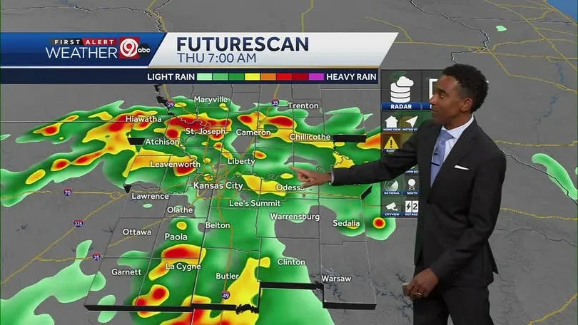
Kansas City is bracing for strong thunderstorms overnight, bringing with them a risk of flooding that could impact local neighborhoods. According to KSHB 41 Weather, residents should prepare for potential severe weather that could disrupt evening activities and cause hazardous conditions on the roads.
Current Weather Conditions
As of today, the atmosphere is ripe for thunderstorms, driven by warm, moist air moving into the region. This has created an unstable weather environment that typically precedes severe thunderstorms. Meteorologists at KSHB 41 predict that storms will develop late in the evening, with the possibility of heavy rain, damaging winds, and even hail.
Flooding Concerns
The primary concern with these overnight storms is the potential flooding risk. The National Weather Service has issued a flood watch for parts of the Kansas City metro area, advising residents to stay alert as heavy rainfall could cause creeks and streams to rise rapidly.
The forecast highlights the threat of localized flash floods, especially in areas with poor drainage or near water bodies. It is advised that residents monitor weather updates and prepare for the possibility of road closures or evacuation orders in extreme cases.
What to Expect Overnight
Temperature readings are expected to remain warm overnight, with highs reaching into the 80s before the storms arrive. After sunset, temperatures will drop slightly, but the humidity levels will make it feel significantly warmer than it is. Winds could gust up to 30 mph during storms, providing an added hazard for those outdoors.
As the storms move through the region, residents can expect to hear thunder and see lightning, which may be intense at times. The rain itself could fall at a rate of 1-2 inches per hour, compounding the risk of flooding.
Looking Ahead to Wednesday
After the storms pass, a significant heat wave is anticipated in Kansas City. Following their departure, temperatures are expected to soar as a high-pressure system builds in from the southwest, leading to what forecasters are calling a ‘heat dome’ effect.
The heat will build significantly throughout the day on Wednesday, July 16, with predictions for high temperatures climbing into the upper 90s, coupled with high humidity that can push the heat index even higher, possibly into the low 100s.
Preparation Tips for Residents
In light of the potential severe weather, Kansas City residents are urged to take the following precautions:
- Stay Informed: Keep a close watch on weather forecasts and alerts from trusted sources. The KSHB 41 Weather App can provide real-time updates.
- Emergency Preparedness: Ensure your emergency kit is ready, including flashlights, batteries, food, water, and medications. Have a plan for your family in case of severe weather.
- Secure Outdoor Items: Bring in or secure any outdoor furniture, decorations, and trash cans that could become projectiles in high winds.
- Avoid Flooded Areas: Do not attempt to drive through flooded roads. Turn around, don’t drown.
Community Response and Resources
Local agencies and emergency services are on standby for any weather-related emergencies and are coordinating with the National Weather Service for updates. Residents can also rely on community resources, such as local shelters and the Kansas City Office of Emergency Management, for support during severe weather events.
Conclusion
Kansas City is gearing up for a turbulent night as storms approach, followed by rising heat levels in the coming days. Staying prepared and informed is crucial for navigating the challenges that volatile weather can bring. Remember, safety comes first—monitor your surroundings and take necessary precautions to protect yourself and your loved ones during this severe weather event.


