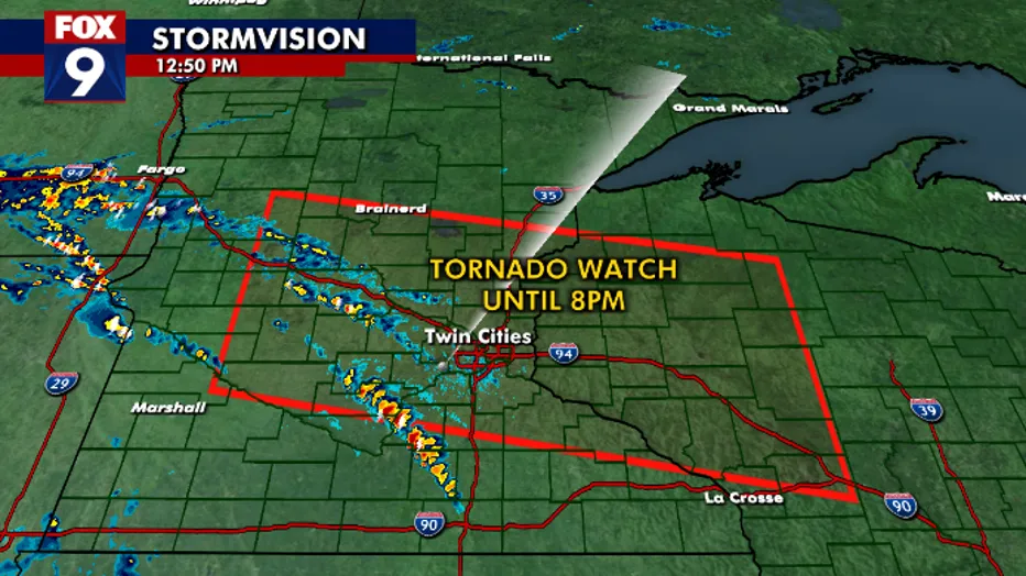
Tornado Watch Issued for Parts of Minnesota and Wisconsin
Severe weather alerts have been issued for various areas across Minnesota and parts of Wisconsin as a tornado watch has been declared for the Twin Cities, St. Cloud, and Brainerd. Residents are urged to stay vigilant as conditions may lead to tornadoes that could be strong and damaging.
What Does a Tornado Watch Mean?
A tornado watch indicates that conditions are favorable for the formation of tornadoes in the designated area. It does not mean that a tornado has been spotted but rather that meteorological conditions are conducive for severe thunderstorms capable of producing tornadoes. People living in a tornado watch area should remain alert for updates from the National Weather Service (NWS) and local authorities.
Where Is the Tornado Watch in Effect?
The tornado watch covers several areas in Minnesota, including:
- Hennepin County (Twin Cities area)
- Stearns County (St. Cloud)
- Crow Wing County (Brainerd)
- And other surrounding counties
In addition to Minnesota, a portion of Wisconsin lies under the same watch, emphasizing the widespread nature of this severe weather warning.
Timeline of the Severe Weather
The threat of severe storms extends through the evening hours, with a particular focus on conditions worsening until approximately 8:00 P.M. local time. Meteorologists have indicated that the most potent storms may be expected during the peak heating hours of the day. As moisture builds up and air rises, the potential for strong thunderstorms—and, consequently, tornadoes—is greatly increased.
What Residents Should Do
As a tornado watch is in effect, all residents in the impacted areas should:
- Stay Informed: Keep track of the latest weather updates through local news broadcasts, radio, and weather apps. The National Weather Service provides real-time updates and alerts.
- Have a Plan: In case a tornado warning is issued, have a safety plan in place. This includes designating a safe room or area in your home where family members can gather.
- Prepare an Emergency Kit: Ensure your emergency kit is stocked with essentials such as water, non-perishable food, flashlights, batteries, first aid supplies, and important documents.
- Identify a Safe Location: If you must evacuate, know your route to a designated shelter in your area. Familiarize yourself with local shelter locations ahead of time.
Possible Hazards Associated with Severe Weather
The severe storms predicted in the coming hours could bring a variety of hazards beyond tornadoes. Dangerous winds, heavy rainfall, and hail are all possible. Here’s what to look out for:
- Damaging Winds: Winds exceeding 60 mph can cause significant destruction, uprooting trees, damaging roofs, and creating flying debris that can pose a deadly risk.
- Heavy Rainfall: Excessive rainfall can lead to flash flooding, especially in areas with poor drainage. Make sure to avoid flooded roads and move to higher ground if necessary.
- Hail: Severe storms may produce hail, which can range from pea-sized to baseball-sized, potentially causing property damage and injury.
Community Preparedness Efforts
Local emergency response teams have been activated and are on stand-by. In many communities, storm spotters trained by the National Weather Service will be out assessing conditions and reporting any active tornadoes or severe damage. Staying connected with your local emergency management office can provide additional reassurance during such turbulent weather.
Conclusion: Stay Safe and Prepared
Tornado watches are serious notifications indicating the potential for dangerous weather conditions. As Minnesota and Wisconsin brace for possible severe storms and tornado activity, it’s essential to remain prepared and informed. Follow the guidance of local authorities and take the necessary precautions to ensure your safety and the safety of your loved ones.
Remember, preparedness is key in severe weather situations, and knowing how to respond can save lives. Keep monitoring local forecasts and stay safe!


